Our story
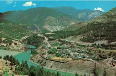
Lytton First Nation is located on 14,161 acres of land divided into 56 reserves. The reserves are located at the site of the Indian Village of TlkemchEEn, meaning, “where the rivers meet”. Commissioner O’Reilly allotted the reserves on August 24, 1881.
Geographically located along the Trans-Canada Highway, between the towns of Hope and Cache Creek, the Lytton First Nation reserves are scattered along a 100-kilometer radius on both sides of the Fraser River.
The Lytton First Nation is rich in natural resources. Water availability is perhaps one of the most significant natural resources available to the Nation. The Stein River water system meets the water needs of a large proportion of community members while other community wells provide water to other members. Natural spring waters are available in various areas.
Various minerals, including gold, jade, copper and others, can still be found within the Lytton First Nation traditional territory. The area is inhabited by numerous species of wildlife, plants, medicines and natural foods. The natural diet of Lytton First Nation members includes deer, moose, salmon, trout, bears, sheep, wild potatoes, wild celery, pine mushrooms, various other mushroom species, numerous seeds, and an abundance of berries.

Gallery
Our Signature Aesthetic


